Birds learn how to fly, never knowing where the flight will take them.
~Mark Nepo
This is a brief update on the recent posts where I shared a few sightings of tagged birds – one, a Common Raven in Yellowstone, and three American Oystercatchers on Masonboro Island in southeastern North Carolina. First, the shorebirds at Masonboro. When I got home, I searched the web for information on banded American Oystercatchers and immediately came up with the American Oystercatcher Working Group. This is a conservation group of scientists and resource managers created in 2001 to monitor oystercatcher population dynamics and promote the conservation of American Oystercatchers and their habitats. Their web site has information on reporting sightings of banded birds so I submitted my data. Once they verify your observations and the leg band ID, you receive information on the birds you reported.
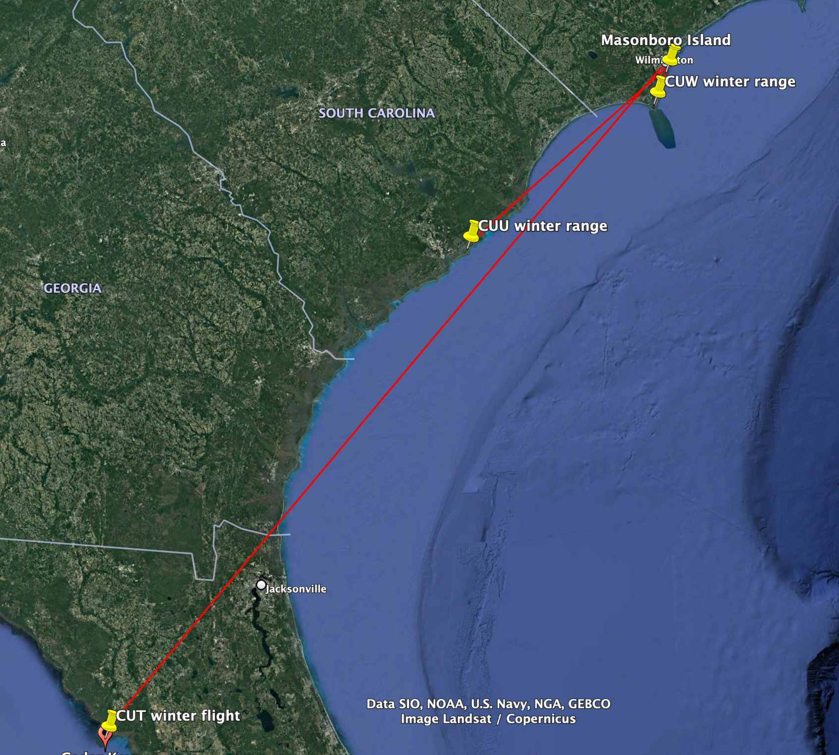
Here are the three birds and what we know of their stories…

CUU was captured and banded on 4/26/16 on Masonboro Island. There have been 33 reported sightings since that time. There are 3 confirmed breeding/nesting seasons on Masonboro (the nest was found); In other years, the bird was seen on Masonboro during the nesting season, but a nest was not observed. Winter sightings were at Dewees Island, near Charleston, SC, in December of 2017 and 2018, a distance of approximately 140 miles from Masonboro.

This is the homebody of the three birds, never having been reported more than 18 miles from Masonboro (on Bald Head Island), even in winter. Captured and banded on 4/26/16 on Masonboro. Reported sightings 43 times. Also has 3 confirmed nests on Masonboro Island and has appeared in that location during the other breeding seasons, but no nest was observed.

The long distance traveler of the group. Captured and banded on 4/26/16 on Masonboro Island. Re-sighted 56 times. Five confirmed nesting seasons on Masonboro (nest found). Observed in Cedar Key, Florida, every winter since it was banded. That is a distance of about 460 miles one way every year.
The map below shows the apparently consistent winter travels of the three American Oystercatchers.
The type of leg band that the oystercatchers had can be viewed and reported from a distance using binoculars, a scope, or a telephoto lens. That type of information gives a data point for any time someone reports seeing the bird. The “tag” on the ravens in the Yellowstone research project includes color coded leg bands for visual observation and a solar-powered GPS backpack with an antenna that submits the birds’ locations every 30 minutes throughout the day. This combination gives a much more detailed view of the birds’ behavior.
The 70 or so tagged ravens are a part of a study looking at interactions of these intelligent birds with their habitat (foraging and roosting sites for example) and with large carnivores (bears, mountain lions, and wolves). In an earlier post, I mentioned I had found out about this research online and had contacted the lead scientist, Dr. John Marzluff. He identified this bird as the female at Tower Junction (the location where she was captured and tagged) with transmitter 7493-2. She was captured on December 10, 2021 and we observed her on 1/20/22 at Tower Junction, patrolling the parking lot at the pit stop and recycle bins.
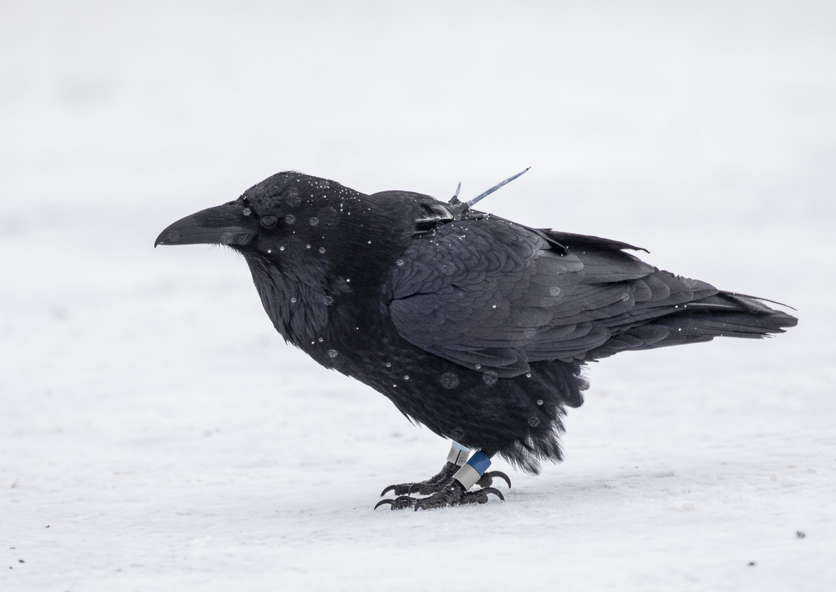

Her data is now visible on the Animal Tracker app (for iPhone and iPad – search for raven and then scroll down to Tower_Junction_female). She tends to move mostly between Tower Junction and Lamar Valley, a distance of about 12 miles. Her longest flight to date has been to an area north of the park entrance along Hwy 89, a distance of about 22 miles. Some of the tagged ravens have dispersed much farther, with one heading up to the Bozeman area, and another, the record-holder, flying up to Alberta, Canada.

Is she going to carcasses in Lamar or just stopping at places where there are concentrations of visitors? I would love to be out there and recording data on these birds to see what they are actually doing. It is a treat to get a peek into the private lives of wildlife. But, more importantly, this is valuable information that may help researchers and resource managers make better decisions for protecting these birds and their important habitats.

Leave a comment